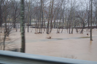
Just a few more of the flood. I'm really tired of high water! This is the Southfork River taken behind some friends' house (Bray's). The left side, just past the trees, is a 40 acre hay field. The river bed runs between the trees and makes a curve right in front of the gazebo. The flooded plain to the right is another hayfield. The picture doesn't show just how far out into the 40 acre field the flood goes, but Sonny said this was the highest he has ever seen the river since they have lived there (about 18 years). You usually have to look down to see the river.
Just to give you an idea of how much rain we have had, flood stage for the White River at Calico Rock is 19 feet, at 8:15 this morning the river was at 34.2 feet. The major highway between Black Rock and Hoxie is closed because the Black River has flooded and is over the highway bridge at Black Rock. If you have ever been that way, you know how serious that is.
The city of Hardy has been evacuated and water is almost up into the city. As of last night the river was 10 feet above flood stage. You can see some of the flooding by going to the following link: www.kait8.com


